October 7, 2026
4:00 pm Update
Local Officials Encourage Visitors to Leave the Area
The Cities of Gulf Shores and Orange Beach are now encouraging non-residents and visitors to leave the area, as well as residents in low-lying and flood-prone areas.
At this time, a mandatory evacuation order has not been issued. Young’s Suncoast’s normal cancellation policy therefore remains in effect until further notice.
Guests with upcoming reservations who purchased travel insurance and choose to cancel should contact their travel insurance provider directly regarding coverage and the claims process.
For guests who did not purchase travel insurance and do not wish to travel due to the storm, Young’s Suncoast is continuing to offer the option to reschedule your reservation for a later available date in October 2026. Otherwise, our normal cancellation policy applies.
Should a mandatory evacuation be issued, guests without travel insurance will be eligible for a refund for reservation nights that fall within the period the mandatory evacuation is in effect.
We understand that guests may need to make decisions based on their own circumstances and comfort level. We strongly encourage everyone to continue monitoring the National Hurricane Center and National Weather Service Mobile/Pensacola for official storm information.
Young’s Suncoast will continue monitoring conditions and local emergency guidance closely and will update this page as additional information becomes available.
Weather Update
At 4:00 PM CDT, the center of Tropical Storm Isaias was located near latitude 22.7 North, longitude 92.9 West. Isaias is
moving toward the east-northeast near 8 mph. A continued east-northeastward motion is expected today, followed by a turn toward the northeast and north on Thursday and Friday. On the forecast track, Isaias is expected to pass to the north of the
Yucatan Peninsula on Thursday and make landfall along the U.S. northern Gulf Coast late Friday or early Saturday. Maximum sustained winds are near 65 mph with higher gusts. Isaias is forecast to become a hurricane by Thursday morning, with further strengthening expected through Friday morning.
Tropical-storm-force winds extend outward up to 60 miles from the center.
The estimated minimum central pressure is 994 mb based on NOAA Hurricane Hunter dropsonde data.
Hazards Included
STORM SURGE: The combination of a dangerous storm surge and the tide will cause normally dry areas near the coast to be flooded by rising waters moving inland from the shoreline. The water could reach 5 – 7ft above ground somewhere in the affected areas if the peak surge occurs at the time of high tide. The deepest water will occur along the immediate coast near and to the east of the landfall location, where the surge will be accompanied by large and dangerous waves.
WIND: Hurricane conditions could begin in the Hurricane Watch area late Friday, and tropical storm conditions could begin in the
watch areas by midday Friday.
RAINFALL: From Friday through the weekend, Isaias is expected to produce rainfall amounts of 3 to 7 inches, with localized totals up to 10 inches, across the central U.S. Gulf Coast extending from far southeastern Louisiana to the Florida Panhandle. Rainfall amounts of 1 to 3 inches, with localized amounts up to 5 inches, are possible across much of the Southeast as far north as the Tennessee Valley and the Carolinas. Flash and urban flooding, along with isolated river flooding, will be possible.
TORNADO: Tornado potential will increase as rain bands accompanying Isaias approach the northeastern Gulf Coast Friday evening and overnight. This potential will spread inland on Saturday as Isaias continues northward.
SURF: Swells are expected to affect the northern Gulf Coast late this week. These swells are likely to cause life-threatening surf and rip current conditions.
1:00 pm Update
From the National Hurricane Center and National Weather Service:
Isaias will be a SIGNIFICANT hurricane as it approaches the Gulf Coast.
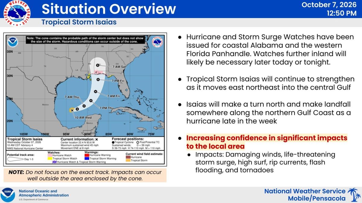
What has changed: Coastal Alabama and the northwest Florida Panhandle are now under a HURRICANE WATCH and a STORM SURGE WATCH. Watches further inland will likely be needed later today or tonight.
IMPACTS: Significant impacts are expected from Isaias including damaging winds, life-threatening storm surge, high surf, rip currents, flash flooding, and tornadoes. A STORM SURGE WATCH has been issued for life-threatening storm surge of 5-7 feet along the coast Friday afternoon to Saturday morning. Heavy rainfall and flash flooding remains a concern, especially along the coast after last weekend’s heavy rainfall/flash flooding. HIGH RISK of rip currents continues through the weekend for coastal Alabama and northwest Florida beaches. Surf builds Friday morning with the potential for 20+ foot breakers late Friday afternoon through Saturday mid-morning to the east of where the center of Isaias tracks. Increasing risk for tornadoes Friday into early Saturday morning to the north and east of where the center of Isaias tracks.
11:30am Update
A Hurricane Watch is now in effect for our area as Tropical Storm Isaias is forecast to approach the northern Gulf Coast later this week.
Young’s Suncoast is actively monitoring the storm and making preparations for our properties, guests, and staff. Because tropical weather forecasts can change quickly, we strongly encourage all guests with upcoming reservations to follow the National Hurricane Center (NHC) and National Weather Service Mobile/Pensacola for the latest official information regarding the storm’s track, timing, intensity, and potential local impacts.
Guests With Upcoming Reservations
At this time, guests with upcoming reservations should continue monitoring official weather information and watch for additional communication from Young’s Suncoast.
If you are considering cancelling or changing your upcoming stay:
If you purchased travel insurance: Guests who choose to cancel should contact the travel insurance provider directly to determine coverage and begin the claims process. Coverage and claim decisions are determined by the insurance provider.
If you did not purchase travel insurance: Our normal cancellation policy remains in effect. However, due to the current storm threat, Young’s Suncoast is allowing affected guests to reschedule their reservation for a later available date in October 2026. Reservations cannot be moved to November or a later month under this storm-related exception.
What Happens if a Mandatory Evacuation Is Issued?
If local officials issue a mandatory evacuation, guests without travel insurance will be refunded for reservation nights that fall within the period the mandatory evacuation is in effect.
A Hurricane Watch, Hurricane Warning, or forecasted storm impact does not by itself constitute a mandatory evacuation.
Please Continue to Monitor Official Updates
Conditions and forecasts may change as Tropical Storm Isaias approaches the Gulf Coast. Young’s Suncoast will continue monitoring the situation and will provide additional information to our guests as necessary.
For the most current storm information, please follow:
National Hurricane Center (NHC)
National Weather Service Mobile/Pensacola
If you have questions regarding your Young’s Suncoast reservation, please contact our Reservations team at 251-968-7158.
Please check this page for additional Young’s Suncoast updates as conditions develop.